 Vacation Tours of Ireland
The Dingle Peninsula: A Guide to Ireland's West Kerry Coast
The Dingle Peninsula is the northernmost of County Kerry's Atlantic peninsulas and one of the strongest reasons to add a night or two on Ireland's west coast. This guide covers the peninsula from Dingle town to Dunmore Head, the Slea Head Drive stop by stop, the Blasket Islands, Conor Pass and Inch Beach. Here the focus is the peninsula itself, where to stop and how long it takes. The bookable tours are compared on all vacation tours of Ireland.
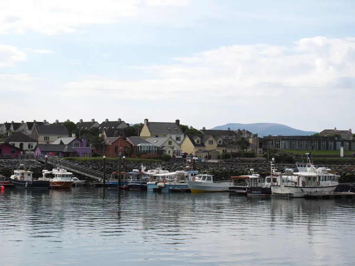
Boats moored in Dingle harbour with the town behind. Photo: Hajotthu, CC BY-SA 3.0, via Wikimedia Commons
Quick answer Dingle Peninsula in brief
The Dingle Peninsula is a 583 km2 finger of County Kerry whose western tip at Dunmore Head is the westernmost point of mainland Ireland. Its Irish name is Corca Dhuibhne, the tribe of Duibhne. Dingle town sits about 50 km southwest of Tralee and 71 km northwest of Killarney, and the coast road loop from town is the Slea Head Drive. The western end is a Gaeltacht, an Irish-speaking district.
Key takeaways
- The 4-Day South West Ireland Tour from Dublin spends a night at Annascaul on the Dingle Peninsula, with three nights of accommodation and breakfast from $568.20.
- For a fuller west-coast week, the 7-Day Ireland to Island Small Group Tour from Dublin covers Kerry, Clare and Galway in a group of up to 12 for $2,823.90.
- The comparison table of multi-day Ireland vacation tours shows which routes include a Dingle night and which skip it.
- Driving Slea Head Drive yourself? Read the guide to driving in Ireland first, because parts of the loop are single lane.
The Peninsula at a Glance
The key figures for the Dingle Peninsula, taken from Wikipedia, the official Dingle Peninsula tourism site and the Office of Public Works.
Key Facts and Figures
The table pulls together the numbers that shape a visit: the size of the peninsula, the height of its mountain pass and the cost of the main ticketed sight. Use it to plan how many nights to give the area, then read the Slea Head Drive section below for the stops in order.
| Fact | Figure |
|---|---|
| Area of the peninsula | 583 km2 |
| Irish name | Corca Dhuibhne, the seed or tribe of Duibhne |
| Westernmost point | Dunmore Head, 52.1086 N, 10.4817 W, westernmost of mainland Ireland |
| Dingle town population | 1,671 residents at the 2022 census |
| Dingle to Killarney by road | About 65 km, around 1 hour 8 minutes by car |
| Conor Pass height | 456 m (1,496 ft), the highest mountain pass in Ireland |
| Mount Brandon | 951 m, second-highest peak outside MacGillycuddy's Reeks |
| Blasket Centre admission | €5 adult, €4 senior, €3 student, €13 family, under 12 free |
Dingle Town and Its Irish Name
Dingle town is Daingean Uí Chúis in Irish, and it sits inside the Gaeltacht where 13.7 percent of residents spoke Irish daily in 2016. A 2006 plebiscite backed the bilingual name by 1,005 of 1,086 ballots, so the town holds both names officially. It has been a fishing port since medieval times and the harbour is still a working one.
Fungie, the bottlenose dolphin that drew visitors to Dingle Bay from 1983, vanished in 2020, so no boat trip today can promise him. If Dingle is new to you, the page on where to stay in Ireland covers the base-town question in depth.
The Slea Head Drive Stop by Stop
The Slea Head Drive is a circular route on the Wild Atlantic Way that starts and ends in Dingle town. The official tourism site tells visitors to drive it clockwise to avoid tour buses, to allow at least half a day, and to follow road signs over sat-nav.
Before You Set Off
The route passes Ventry Beach, prehistoric forts, beehive huts, the Famine Cottage and Gallarus Oratory, with Slea Head itself offering a full view of the Blasket Islands. Local roads on the loop have single-lane sections, and the official advice is to leave 1.5 m when passing walkers and cyclists. The official tourism site lists no total length in kilometres, so plan by time rather than distance.
Half a day is the stated minimum, and a full day is better if you want to stop at the ticketed sights.
Ventry and Dún Beag Fort
Ventry is the first stop out of Dingle on the clockwise loop. Just beyond it sits Dún Beag, an Iron Age promontory fort near Ventry with a wall 15 to 25 feet thick. Cliff erosion has taken part of the site, and the fort entrance itself was closed to visitors as unsafe after storm damage in 2017 and 2018.
A visitor centre with audiovisual displays remains, so you can still visit the site and learn its story even though you cannot walk into the fort itself. Dún Beag is one of the stops listed by the official Dingle Peninsula tourism site, alongside the beehive huts at Fahan, Louis Mulcahy Pottery, Coumenoole Strand, Gallarus Oratory and the Blasket Centre.
The Beehive Huts at Fahan
The Fahan beehive huts are clocháin, dry-stone corbelled huts scattered across the fields around Fahan. 414 clocháin have been counted in the area and most are believed to date from the 12th century. Their age is a live debate, with some sources suggesting far earlier origins, but the Wikipedia figure of mostly 12th century is the one that can be checked.
Slea Head and Dunmore Head
Slea Head itself is built of steeply dipping Devonian sandstones and conglomerates, traditionally called Old Red Sandstone, and it looks straight out at the Blasket Islands. David Lean filmed Ryan's Daughter in spring and summer 1969, largely on the peninsula and including the beach between Slea Head and Dunmore Head. A short drive further brings you to Dunmore Head at 52.1086 N, 10.4817 W, the westernmost point of mainland Ireland.
The Spanish container ship MV Ranga ran aground near here on 11 March 1982 after losing power in a storm.
The Great Blasket Centre and the Blasket Islands
The Blasket Islands, Na Blascaodaí, are six islands: Great Blasket, Inishtooskert, Inishvickillane, Inishnabro, Tearaght and Beginish. They have been uninhabited since the government moved most Great Blasket residents out in November 1953 after a harsh winter, with the last family leaving in 1954. Great Blasket covers 455 ha and its writers Tomás Ó Criomhthain, Muiris Ó Súilleabháin and Peig Sayers published island memoirs in 1929, 1933 and 1939. The Office of Public Works bought most of the island's property in 2009 and guided tours of the island began in 2010.
The Great Blasket Centre (Ionad an Bhlascaoid) in Dún Chaoin is 16 km from Dingle and opens daily 10:00 to 18:00 from 6 March to 8 November, with last admission at 17:15. Admission is €5 for adults, €4 for seniors and groups, €3 for students and €13 for a family, and children under 12 go in free. The centre was fully renovated in 2022 with interactive exhibitions and has a clifftop viewing platform, a cafe and a bookshop.
Blasket Island ferries from near Dunquin run April to October according to the official peninsula site. One operator departs from Ventry Pier on the drive and lists a 7 hour Blasket tour that includes 3 hours ashore on Great Blasket. Crossing times are not stated on record, so confirm on the day.
Gallarus Oratory and the Forts
Gallarus Oratory is the best-known early building on the peninsula, a dry-stone corbel-vaulted structure about 4.8 m by 3 m inside with walls 1.2 m thick at the base and a single small round-headed window. Its date is genuinely unsettled: it was first described as early Christian in 1756, later dated to the 12th century, and since the 1990s has also been read as a pilgrim shelter. That argument is part of the appeal.
The oratory pairs naturally with the promontory fort at Dún Beag described above, and with the ring of clocháin, to give the loop its ancient-stone thread. If standing stones and forts are your reason for coming west, the guide to castles in Ireland puts these earlier monuments in context against the later tower houses.
Conor Pass, Mount Brandon and the North Shore
North of Dingle the R560 climbs to 456 m (1,496 ft) at Conor Pass, which Wikipedia calls the highest mountain pass in Ireland. It links Dingle with Castlegregory on the north coast and runs between the peaks Binn Dubh and Sliabh Mhacha Ré. The road is single-lane asphalt used in both directions, so when two vehicles meet one must reverse to the nearest wider section, and vehicles over two tonnes are prohibited.
Mount Brandon, at 951 m, is the second-highest peak outside MacGillycuddy's Reeks. The north shore and the Blasket Islands ferry are named by the peninsula tourism site alongside Slea Head Drive as the headline visitor draws, so an extra day lets you cover both sides of the peninsula rather than squeezing them into one.
Conor Pass, Brandon and Inch
The peninsula is more than Slea Head. The north side has the highest mountain pass in Ireland and the south shore has a 5 km Blue Flag beach.
Conor Pass
The Conor Pass (R560) climbs to 456 m between Dingle and Brandon Bay, and Wikipedia calls it the highest mountain pass in Ireland. It links Dingle with Castlegregory on the north coast and runs between the peaks Binn Dubh and Sliabh Mhacha Ré.
It is a single-lane asphalt road used in both directions. When two vehicles meet, one reverses to the nearest wider section. Vehicles over two tonnes are prohibited on the road. Take it slowly and read the driving in Ireland advice before you set out.
Mount Brandon
Mount Brandon rises to 951 m and is the second-highest peak in Ireland outside MacGillycuddy's Reeks.
The peninsula covers 583 km2 in total. Its Irish name Corca Dhuibhne means the seed or tribe of Duibhne. The land west of Dingle town is a Gaeltacht, an Irish-speaking area.
Inch Beach
Inch Strand is a spit about 5 km long on the south side of the peninsula. It is a Blue Flag beach and sits in a Special Area of Conservation, so it makes an easy stop as you arrive or leave.
Parts of David Lean's Ryan's Daughter were filmed on the peninsula in 1969, including the beach between Slea Head and Dunmore Head. For more screen and history stops, see the guide to castles in Ireland.
Sources: Wikipedia, Conor Pass, Inch
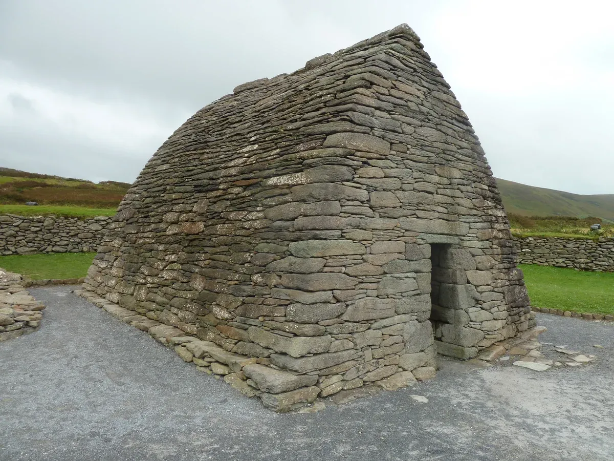
The dry-stone Gallarus Oratory near Ballydavid. Photo: Draceane, CC BY-SA 4.0, via Wikimedia Commons
Getting There and How Long to Stay
Dingle has no railway, so you arrive by car or bus. The nearest stations are Tralee and Killarney, and the multi-day tours below put Dingle on the route so you do not have to drive back the same day.
Distances and Drive Times
Dingle town sits about 50 km southwest of Tralee and 71 km northwest of Killarney. By road, Dingle to Killarney is about 65 km and takes around 1 hour 8 minutes by car. From Dublin the peninsula association puts the drive at about 350 km and 4h 15m.
The Tralee and Dingle Light Railway closed in 1953, so Tralee is the nearest rail terminal today. Killarney station has direct services to Tralee, Cork and Dublin, which suits a longer Ireland itinerary.
Buses
Bus Eireann route 275 and TFI Local Link routes 273 and 274 serve the Cliff Coast region that includes Dingle and Tralee. Exact Dingle bus journey times and frequencies are not stated in the sources, so check Transport for Ireland before you travel. Kerry Airport is also linked to Dingle by bus.
If you would rather skip the buses entirely, the guided options below start in Dublin.
Tours That Overnight in Dingle
Several multi-day tours from Dublin include a night or two on the Dingle Peninsula. The table compares where the itineraries state overnight stops in Dingle and what each costs. The full side-by-side comparison of vacation tours of Ireland lives on the homepage.
For seasonal planning around these routes, see the best time to visit Ireland.
| Tour | Nights in Dingle | Price |
|---|---|---|
| 5-Day South West Ireland Tour | None, Dingle is a day 3 trip from Killarney | $1,464.67 |
| 6-Day All Ireland Tour | 1 of 5 nights (Dingle Peninsula listed) | $1,023.66 |
| 4-Day South West Ireland Tour | 1 of 3 nights (Annascaul, Dingle Peninsula) | $568.20 |
| 10 Day Wild Irish Experience | Two-night stay in Dingle | $3,301 |
How Long to Stay
The official peninsula tourism site says to allow at least half a day for the Slea Head Drive alone. Add the Conor Pass, Inch Strand and a Blasket boat trip and a full day fills quickly, so two nights is a sensible minimum. Dingle town had 1,671 residents at the 2022 census and its harbour is still a working fishing port, so there is enough in town for an evening on foot.
If your days are limited, the day trips from Dublin guide covers what works in one day, and where to stay in Ireland covers the base question. One dolphin note: Fungie lived in Dingle Bay from 1983 until he vanished in 2020, so no current boat trip can promise him.
Sources: Dingle, Transport for Ireland, dingle-peninsula.ie
Where to Sleep on the Peninsula
Each link opens the live room list. Dingle town has the harbour, the pubs and the boats, and Killarney is the larger base an hour or so away.
Dingle town
- Suits
- Walking to the harbour and starting the Slea Head Drive early
The loop from Dingle passes Ventry, Dún Beag, Slea Head and the Great Blasket Centre.
See stays in Dingle townKillarney
- Suits
- Combining Dingle with the Ring of Kerry and the national park
Dingle town is about 71 km from Killarney by road.
See stays in KillarneyFrequently Asked Questions
What movie was filmed on the Dingle Peninsula?
Ryan's Daughter, David Lean's 1969 film, was largely filmed on the peninsula in spring and summer 1969, including the beach between Slea Head and Dunmore Head. The peninsula sits on the Wild Atlantic Way.
What islands lie off the coast of Dingle?
The Blasket Islands, six islands named Great Blasket, Inishtooskert, Inishvickillane, Inishnabro, Tearaght and Beginish. Ferries from near Dunquin run April to October, and one operator from Ventry Pier lists a 7 hour tour with 3 hours ashore on Great Blasket. Guided tours of the island began in 2010 after the Office of Public Works bought most of the property in 2009. Compare this with the Aran Islands and Cliffs of Moher tour from Galway.
Can you drive the Conor Pass?
Yes, in ordinary cars. The R560 climbs to 456 m and is single lane in places, so one vehicle may need to reverse to a wider section, and vehicles over two tonnes are prohibited. Read the driving in Ireland guide before you go.
How do I get to the Dingle Peninsula without a car?
Tralee is the nearest rail terminal since the local railway closed in 1953. Buses link Dingle with Killarney, Tralee and Kerry Airport, including Bus Eireann route 275 and TFI Local Link routes 273 and 274. Dingle to Killarney is about 65 km by road. The 4-Day South West Ireland Tour covers the peninsula by coach from Dublin.
How long should I stay on the Dingle Peninsula?
Allow at least half a day for the Slea Head Drive on its own, per the official tourism site, and a full day or two to add the Conor Pass, Inch Beach and the Blasket Centre. The 10 Day Wild Irish Experience stays two nights in Dingle.
Is a guided tour of Kerry better than the Ring of Kerry?
They are different routes. The Dingle Peninsula is north of the Ring of Kerry, a separate 179 km loop through Killarney, Kenmare, Sneem, Waterville, Cahersiveen and Glenbeigh. If you want that loop instead, see the Ring of Kerry Tour from Killarney page.